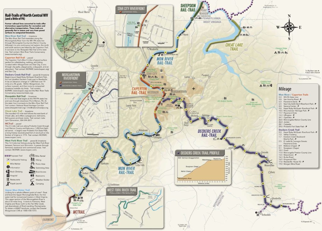
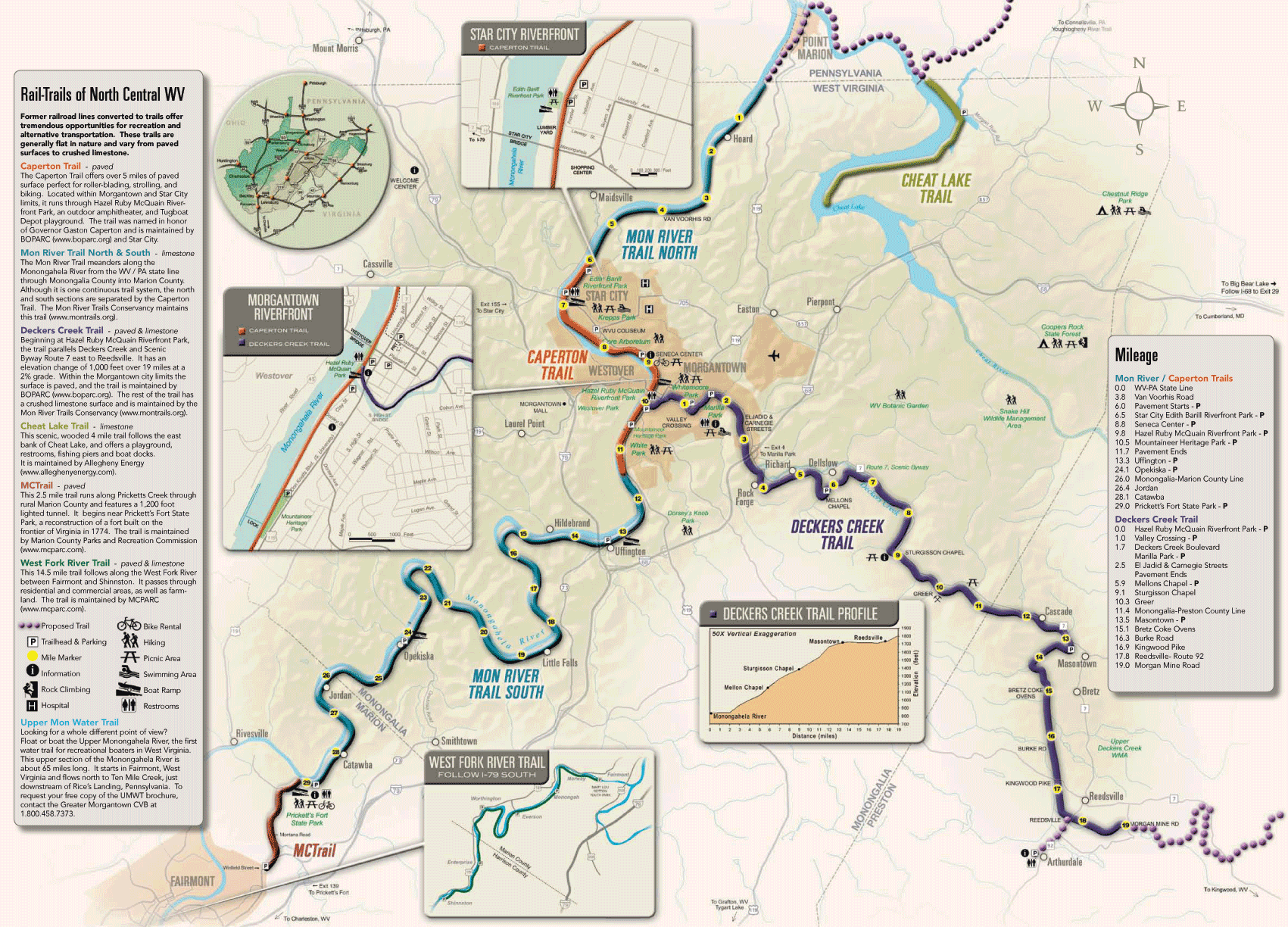
DECKERS CREEK RAIL-TRAIL
Trail Location: Morgantown to Reedsville
Trail Length: 19.5 miles
Counties: Monongalia, Preston
Nearby Towns: Morgantown, Sabraton, Masontown, Reedsville, Arthurdale
Trail Surface(s): Asphalt (3 miles), Compacted limestone (16.5 miles)
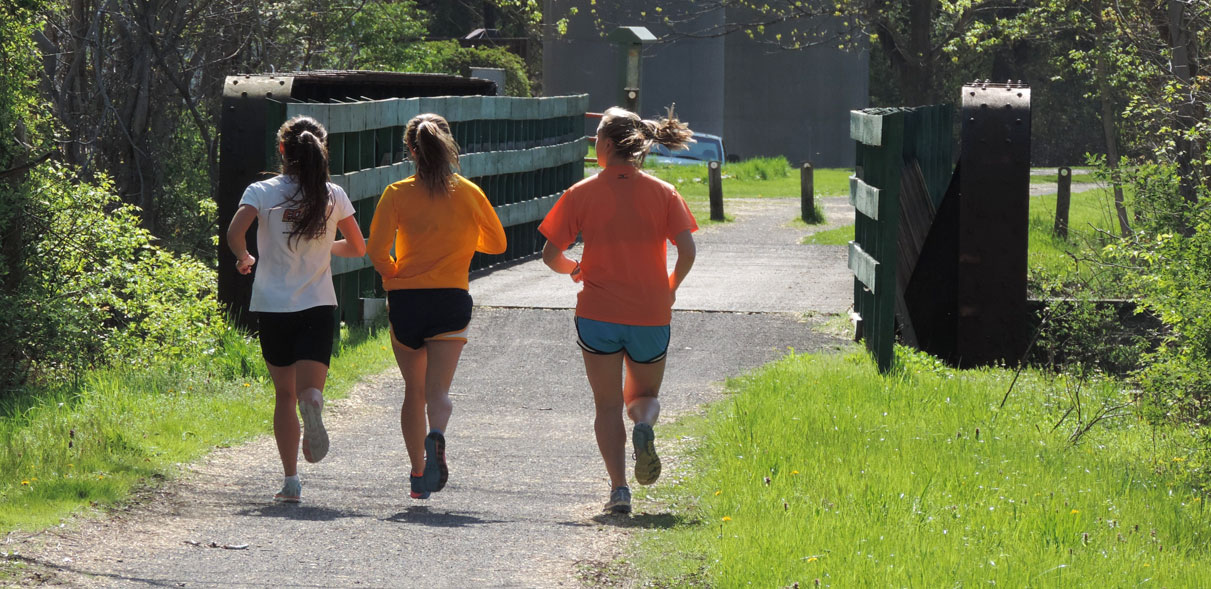
Activities: Walking, Biking, Cross Country Skiing, In-line Skating (on asphalt), Handicap Accessible
Trail Description:
Beginning at Hazel Ruby McQuain Riverfront Park in Morgantown, the trail parallels Deckers Creek and Scenic Byway Route 7 East to slightly west of Reedsville, WV in Preston County. From the confluence of Monongahela River in Morgantown, the rail-trail follows scenic Deckers Creek upstream with noticeable elevation change of 1,000 feet over 19 miles. In Morgantown city limits, the trail is asphalt, outside Morgantown the trail is surfaced with a smooth crushed limestone. This trail provides easy access to Marilla Park, a Morgantown city park with a swimming pool, tennis courts, and playground as well as neighboring restaurants & grocery stores. Outside of Morgantown city limits, the landscape becomes very scenic and secluded with hardwoods, hemlock & rhododendron, and rock outcroppings. The trail provides a close-up view of Greer Limestone, an active limestone mine. Highly-experienced kayakers paddle Deckers Creek, which has some Class VI rapids and rock climbing is also popular in the region. The trail currently ends just beyond Morgan Mine Road. Less than a mile from the trail on Route 92 is the Arthurdale Heritage District and Museum. The entire community of Arthurdale is on the National Register of Historic Places, recognized as the Nations First New Deal Homestead Community.
Parking & Trail Access:
There is parking available in Morgantown at Hazel Ruby McQuain Park and in Sabraton at Marilla Park, Breakiron Road in Rock Forge, Masontown and Reedsville also have trailheads with parking.
MON RIVER RAIL-TRAIL (north section)
Trail Location: WV/ Pennsylvania State Line to Star City, WV
Trail Length: 6 miles
Counties: Monongalia
Nearby Towns: Star City, Morgantown
Connections: Sheepskin Trail at the state line continues an additional 3 miles
Trail Surface: Compacted limestone
Activities: Walking, Biking, Cross Country Skiing, Handicap Accessible
Trail Description:
The trail follows along the Monongahela River from Star City to the Pennsylvania state line.
Parking & Trail Access:
There is parking available in Star City at the Edith Barill Riverfront Park and Van Voorhis Trailhead at the end of Van Voorhis Road.
MON RIVER RAIL-TRAIL (south section)
Trail Location: Morgantown city limits to Pricketts Fort State Park
Trail Length: 18 miles
Counties: Monongalia, Marion
Nearby Towns: Morgantown, Fairmont
Connections: Links to Marion County Trail at Prickett’s Fort State Park
Trail Surface: Compacted limestone
Activities: Walking, Biking, Cross Country Skiing, Handicap Accessible
Trail Description:
This trail is a wooded, river valley trail from the Morgantown city limits in Monongalia County to Prickett’s Fort State Park in Marion County. The trail is 17.7 miles long with 14.7 miles in Monongalia County and the remaining 3 miles in Marion County. It is one continuous trail system, the Mon River Rail-Trail north and south sections are linked by the Caperton Trail. The Mon River Rail-Trail has a crushed limestone surface that is comfortable for wheelchairs, strollers, and tricycles. The trail follows a wooded river valley with many scenic river views, occasional waterfalls, and a variety of wildflowers in the spring and autumn.
Parking & Trail Access:
There is parking available at the Uffington Trailhead, Opekiska Trailhead and Prickett’s Fort Trailhead.
CAPERTON RAIL-TRAIL
Trail Location: Morgantown
Trail Length: 6 miles
Counties: Monongalia
Nearby Towns: Morgantown, Star City
Trail Surface: Asphalt
Activities: Walking, Biking, Cross Country Skiing, In-line Skating, Handicap Accessible
Trail Description:
This trail offers 6 miles of paved surface, perfect for rollerblading, walking, and biking. Located within the Star City and Morgantown city limits, this trail runs through the Edith Barill Park, the WVU Core Arboretum and the Hazel Ruby McQuain Riverfront Park. The Caperton Trail is an urban trail with easy access to neighboring restaurants and shopping areas in Morgantown and Star City. The trail was named in honor of Governor Gaston Caperton and is maintained by BOPARC.
Parking & Trail Access:
There is parking available in Morgantown at Hazel Ruby McQuain Riverfront Park (metered parking) and parking garage in the Wharf District, and trailhead parking at Mountaineer Heritage Park (beside Waterfront Jeep). In Star City there is parking at Edith Barill Riverfront Park and at the Star City Trailhead.
PLAN A TRAIL ADVENTURE
To plan a trip, get a trail map, and discover other area attractions, contact the Visit Mountaineer Country Convention and Visitors Bureau at 800-458-7373 or www.visitmountaineercountry.com. Rail-Trail maps and Upper Mon River Water Trail maps are available and can be mailed to you. Watch a video of the fun that can be found in Morgantown.